Traveling Trail Ridge Road

Experience Tail Ridge Road Scenic Drive
Trail Ridge Road in Colorado is a marvel of nature and engineering. Spanning 48 miles, it's the highest continuous paved road in the United States. The road offers breathtaking mountain views and unique high-altitude experiences. It's a must-see destination for travelers, nature enthusiasts, and road trippers. However, a trip to Trail Ridge Road requires careful planning. The weather can be unpredictable, and the high altitude presents its own challenges. The best way to enjoy this scenic drive is by being prepared. This means being prepared with appropriate clothes, having your vehicle ready for the drive, and knowing a bit about the history of Trail Ridge Road so you can fully appreciate the scenic stops and wildlife along the way. Whether you're planning a visit or just curious about this natural wonder, we hope this guide will be informative and inspiring.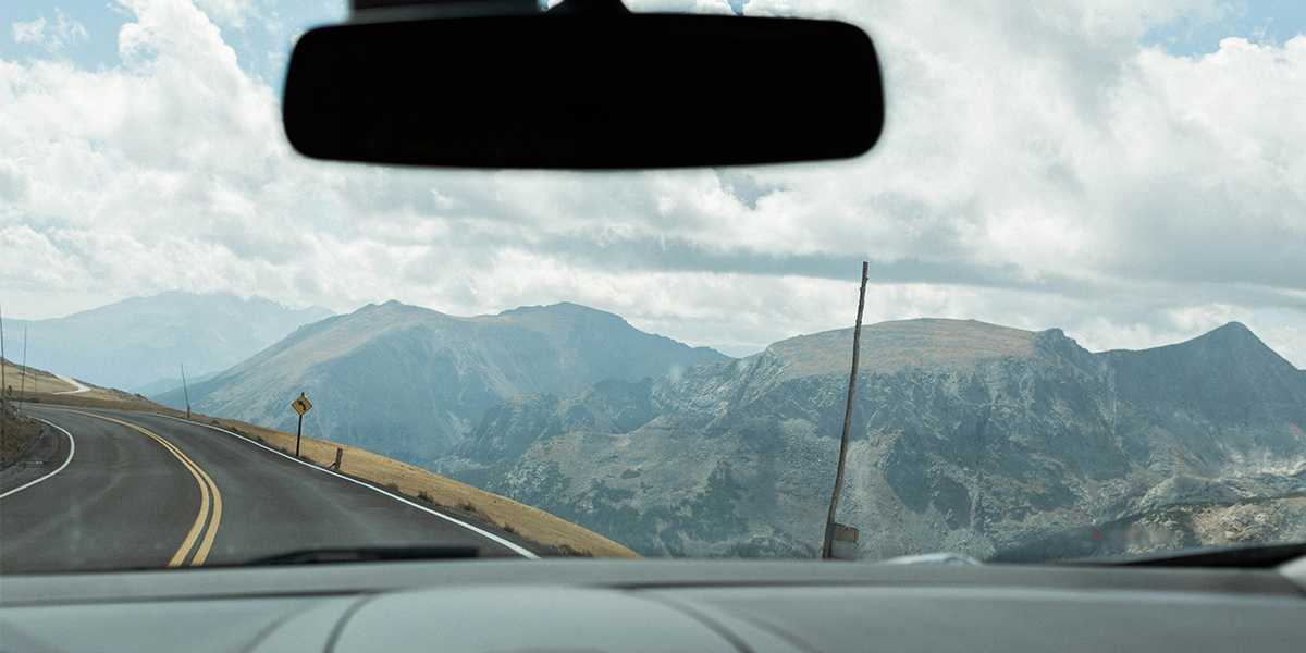
The Highs and Lows of Trail Ridge Road
Trail Ridge Road is a feat of human ingenuity. At its highest point, it reaches 12,183 feet, offering panoramic views of the Rocky Mountains. The road connects Estes Park to the east with Grand Lake to the west. It's part of Rocky Mountain National Park, known for its stunning natural beauty.Crosses the Continental Divide
The road crosses the Continental Divide at Milner Pass. The Continental Divide is a significant geographical feature that separates the watersheds that drain into the Atlantic and Pacific oceans.Various Ecosystems
Driving along Trail Ridge Road, you'll experience a variety of ecosystems. The road offers a unique journey through nature, from montane forests at lower elevations to the alpine tundra at the top. The road's design minimizes the impact on the natural environment. It's a testament to the National Park Service's commitment to preserving and providing access to natural wonders.Preparing for the Journey: Weather and What to Wear
Weather on Trail Ridge Road can be unpredictable. It can change rapidly, and snow can occur at any time of the year at high elevations. Before committing to this drive, always check the weather forecast well in advance. This will help you prepare for the conditions you might encounter. You might even postpone your trip if the weather is predicted to be bad.High-Altitude Sickness
Visitors should also be prepared for high-altitude conditions. The air is thinner at high elevations, which can lead to potential altitude sickness.Here are some tips for what to wear:
- Layered clothing is recommended due to temperature fluctuations.
- Sunscreen is a must, as the sun's rays are stronger at high altitudes.
- A hat and sunglasses can provide additional protection from the sun.
- Comfortable shoes are essential, especially if you plan to explore hiking trails.
Navigating the Scenic Route: Driving Tips and Safety
Driving on Trail Ridge Road is an experience like no other. The road spans 48 miles, connecting Estes Park to the east with Grand Lake to the west. The road has several hairpin turns and steep drop-offs, requiring cautious driving. Nighttime driving is not recommended due to the lack of street lighting and potential wildlife crossings. Trail Ridge Road has no gas stations, so visitors should fill up before the trip. Cell phone reception can be spotty, so bring an actual map. Preparing a vehicle survival kit is a good idea, as well as following basic safety precautions, such as staying hydrated, wearing sunscreen, and driving carefully. Ensure that your vehicle is in top condition. Becoming stranded along this route is not an option. Remember, the journey is as important as the destination. Enjoy the ride!Historical Significance of Trail Ridge Road
Originally, the Trail Ridge route was used by Native Americans to cross the mountains between their homelands in the west and hunting grounds on the eastern slope. The Indians called this pass the “taienbaa," meaning “where the children walked.” Due to the trail's steepness, the children could not be carried and had to walk this section.Fall River Road
Fall River Road was the first road opened in 1921 but quickly proved inadequate. The single-track road had very steel grades up to 16%, tight curves, and often snowpack that lasted late into summer.Final Route
Trail Ridge Road is not just a scenic drive; it's a feat of engineering, as construction faced numerous challenges, such as harsh weather and extreme terrain. Construction was completed in 1932. The final route followed an original trail coined as the Dog Trail by local Arapaho Indians. This route passes through Kawunee Valley and ends at Grand Lake.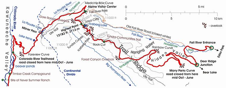
Must-See Stops Along Trail Ridge Road
Trail Ridge Road offers stunning panoramic views of the Rocky Mountains. There are several pull-offs and viewpoints along the road for photo opportunities. The Alpine Visitor Center is located near the road's highest point, marked by the Forest Canyon Overlook. It offers exhibits and information. Many Parks is one of the most photographed views along the road. The Gore Range Overlook provides views of distant peaks that are over 12,000 feet tall.Here are some must-see stops along the road:
- Alpine Visitor Center: The highest visitor’s center in the National Park system at 11,796’.
- Forest Canyon Overlook: Take a 5-minute walk on the paved asphalt trail to see stunning views of Forest Canyon, Hayden Gorge, and Gorge Lakes.
- Many Parks Curve: Stop for a vista of ‘many parks’ (low-land meadows). Moraine Park, Upper Beaver Meadows, and Horseshoe Park meadows are all visible, with Deer Mountain and Longs Peak as backdrops.
- Gore Range Overlook: This stop is a scenic overlook and accesses trailheads for hiking and equestrian use.
- Lava Cliffs overlook: Stop and view a rare section of volcanic rock within RMNP.
Wildlife and Natural Wonders: Flora and Fauna Highlights 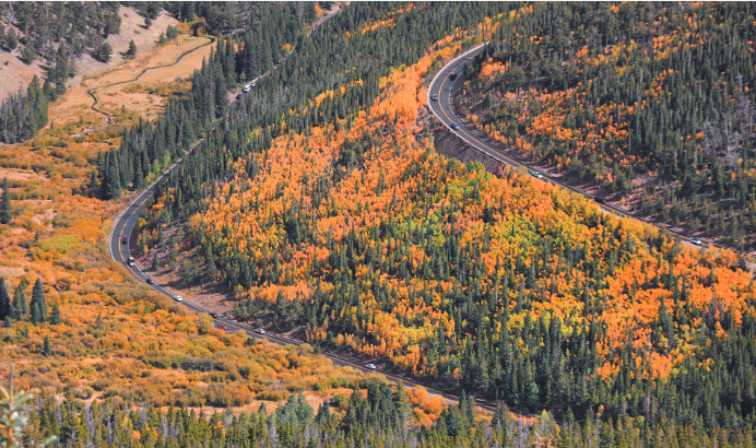
Trail Ridge Road is a habitat corridor for wildlife. Elk, bighorn sheep, and marmots can often be spotted along the road. The road also provides access to various ecosystems, including astounding montane forests and alpine tundra biodiversity. The Continental Divide Trail crosses Trail Ridge Road, providing long-distance hiking and wildlife spotting opportunities. Remember to respect the wildlife and keep a safe distance.
Seasonal Access and Road Closures
Trail Ridge Road is typically open from Memorial Day to mid-October, depending on weather conditions. The road is closed in winter due to snow accumulation up to 20 feet deep.The Unforgettable Experience of Trail Ridge Road
Traveling Trail Ridge Road in Colorado is an unforgettable experience. The road's stunning mountain views, diverse wildlife, and rich history make it a must-see destination. Whether you're a nature enthusiast, a road tripper, or simply someone who appreciates breathtaking landscapes, Trail Ridge Road will leave a lasting impression. The road's beauty and accessibility make it a prime example of the National Park Service's mission to preserve and provide access to natural wonders. It's a testament to human ingenuity and respect for nature's grandeur. Trail Ridge Road offers a unique opportunity to "drive on top of the world." It's a highlight for many visitors to Colorado and is considered a bucket-list item for scenic drive enthusiasts.by Kathleen Fitzsimmons